
Grey Gypsies of Australia
Tasmania


Grey Gypsies of Australia
Tasmania
Crayfish Creek
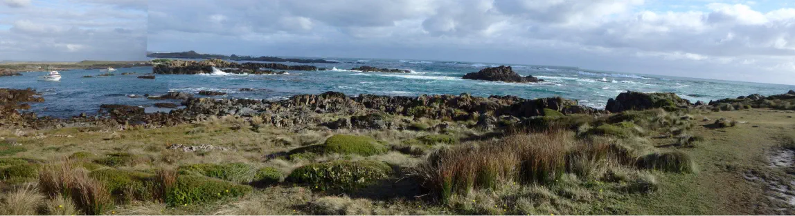
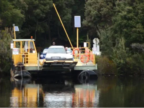
In 2015 we took our trusty Avan over on the ferry to meet up with some fellow travellers. We arrived a week earlier than they. We had a week to explore the
north-west corner. We had nothing booked so we meandered westwards and found a lovely spot at Crayfish Creek to use as a base. We did day trips including
Arthur River, Coutta Rocks
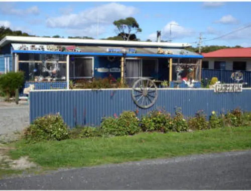
Bullshit Corner:
A cluster of small holiday houses are across the road facing the ocean,
neat well tended gardens with “Bullshit Corner” worth looking up.
This eccentric retirement garden is filled with quirky garden sculpture
made from all sorts of found objects nested amongst dahlias, fuchsias,
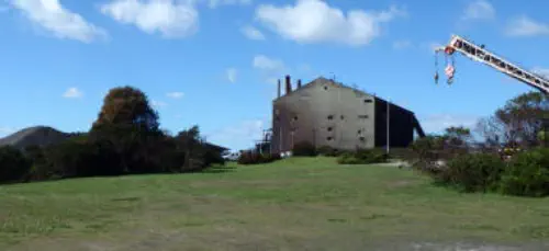
geraniums and small shrubs. Several kilometres down the road is Port
Latta, a huge black hermatite and magnetite processing plant with
loading piers that stretch out into the sea. It’s always lit up at night and seems so strange to see something so
ugly set in amongst the lovely little coves and rocky headlands of the North Coast. We also looked at the free
camping sites at Peggs Beach and Black River on the way to Stanley. Peggs is very exposed to the Roaring
Forties winds, but Black River has a lot of sheltered sites set in amongst trees and was great lunch spot the
next day. Stanley is a picture perfect little Georgian village filled with well restored weatherboard cottages, all
painted in heritage colors. Most people go there to do the chairlift up the Nut and catch the great views. We
liked the coffee, the architecture and the fabulous fish and chipper: xxxxxxx.
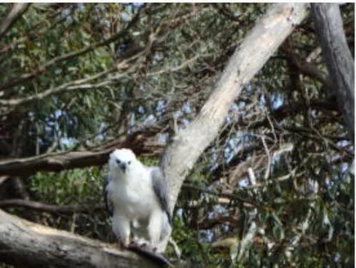
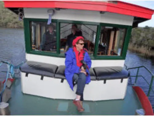
Arthur River Red Boat trip:
Two very helpful guys – Greg and Robert took us up the Arthur River showing us sea
eagles and giving us a history of the unlogged and natural river rainforest and
environs. A walk through the rainforest at Turks Landing gave us the chance to see
the rainforest species of laurel, leatherwood, ironbark and beech, have lunch and
return to the small village of Arthur River, where we drove out to the spectacular sea
vista “the Edge of the World”. Driving down the west coast road we explored Sara Ann
Rocks, Stinking Beach and Couta Rocks. Lots of camp sites along the coast road with
us carefully driving to avoid the the Tassie Devils, apparently the only remaining
population that are free from the facial tumour disease that had killed so many. We didn’t see any at all but were told they
lived in the coastal scrub. Instead we enjoyed the wild small coves and beaches in the blustery winds that are common there.
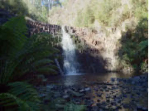
Dip Falls
The best forest drive in the area was to Dip Falls, a long drop of water nestled in a remnant patch of wet rainforest. Stands of tall 3
meter tree ferns, mossy logs and very tall brown stringybarks with short walks gave visitors some idea of the forest before so many
dairy and cattle farms were carved out of it, so much timber was selectively logged and so many hectares of stringybark plantations
replaced the original vegetation. Did some driving on logging tracks but the sights of selectively harvested forests with a lot of trash
left on the ground is very depressing.
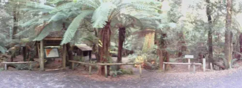
Milkshake Forest Reserve
We also drove the South Arthur Loop road, again with logging coups, farms and plantations replacing a lot of the rainforest. The best spot to see some original
vegetation on this road is the Milkshakes Forest Reserve a green oasis of tree
ferns and massive trees. No camping there, but a great spot for photos, BBQ lunch
or short walks. My conclusion is that most of the wet north west rainforest in
already gone and more is disappearing still as farmers are clearing any rainforest
they have on their blocks to increase their grazing capacity. Tourists are catered for
by leaving ribbons of the original forests along the sides of tourist roads while
behind these strips selective logging continues. This is what is locally known as
“multi use forests”: logging, plantations, tourism and farming.
Corinna
We also drove the Meredith highway from Yolla to Corinna. Along the way Hellyer Gorge had a nice short walk along the river while Phillosphers Falls is a
longer walk we didn’t take due to rain. The Savage River estuary is dominated by the Grange mine which sends its raw ore to Cape Latta for processing. ..We
came back along the Western Explorer road noting a
number of pleasant small campsites not far out of Corinna,
driving through the Pieman Conservation area. Again lots
of cleared acres left vacant, lots of dead trees in places but
some good views


Grey Gypsies of Australia
Tasmania
Crayfish Creek
In 2015 we took our trusty Avan over on the ferry to meet up with
some fellow travellers. We arrived a week earlier than they. We
had a week to explore the north-west corner. We had nothing
booked so we meandered westwards and found a lovely spot at
Crayfish Creek to use as a base. We did day trips including Arthur
River, Coutta Rocks
Bullshit Corner:
A cluster of small holiday houses
are across the road facing the
ocean, neat well tended gardens
with “Bullshit Corner” worth
looking up. This eccentric
retirement garden is filled with
quirky garden sculpture made
from all sorts of found objects
nested amongst dahlias,
fuchsias, geraniums and small shrubs. Several kilometres down
the road is Port Latta, a huge black hermatite and magnetite
processing plant with loading piers that stretch out into the sea.
It’s always lit up at night and seems so strange to see something
so ugly set in amongst the lovely little coves and rocky headlands
of the North Coast. We also looked at the free camping sites at
Peggs Beach and Black River on the way to Stanley. Peggs is very
exposed to the Roaring Forties winds, but Black River has a lot of
sheltered sites set in amongst trees and was great lunch spot the
next day. Stanley is a picture perfect little Georgian village filled
with well restored weatherboard cottages, all painted in heritage
colors. Most people go there to do the chairlift up the Nut and
catch the great views. We liked the coffee, the architecture and
the fabulous fish and chipper: xxxxxxx.
Arthur River Red Boat trip:
Two very helpful guys – Greg and Robert took us up the Arthur
River showing us sea eagles and
giving us a history of the
unlogged and natural river
rainforest and environs. A walk
through the rainforest at Turks
Landing gave us the chance to
see the rainforest species of
laurel, leatherwood, ironbark and
beech, have lunch and return to
the small village of Arthur River, where we drove out to the
spectacular sea vista “the Edge of the World”. Driving down the
west coast road we explored Sara Ann Rocks, Stinking Beach and
Couta Rocks. Lots of camp sites along the coast road with us
carefully driving to avoid the the Tassie Devils, apparently the only
remaining population that are free from the facial tumour disease
that had killed so many. We didn’t see any at all but were told
they lived in the coastal scrub. Instead
we enjoyed the wild small coves and
beaches in the blustery winds that are
common there.
Dip Falls
The best forest drive in the area was
to Dip Falls, a long drop of water nestled in a remnant patch of
wet rainforest. Stands of tall 3 meter tree ferns, mossy logs and
very tall brown stringybarks with short
walks gave visitors some idea of the
forest before so many dairy and cattle
farms were carved out of it, so much
timber was selectively logged and so
many hectares of stringybark
plantations replaced the original
vegetation. Did some driving on logging tracks but the sights of
selectively harvested forests with a lot of trash left on the ground
is very depressing.
Milkshake Forest Reserve
We also drove the South Arthur Loop road, again with logging
coups, farms and plantations replacing a lot of the rainforest. The
best spot to see some original vegetation on this road is the
Milkshakes Forest Reserve a green oasis of tree ferns and massive
trees. No camping there, but a great spot for photos, BBQ lunch
or short walks. My conclusion is that most of the wet north west
rainforest in already gone and more is disappearing still as farmers
are clearing any rainforest they have on their blocks to increase
their grazing capacity. Tourists are catered for by leaving ribbons
of the original forests along the sides of tourist roads while behind
these strips selective logging continues. This is what is locally
known as “multi use forests”: logging, plantations, tourism and
farming.
Corinna
We also drove the Meredith highway from Yolla to Corinna. Along
the way Hellyer Gorge had a nice short walk along the river while
Phillosphers Falls is a longer walk
we didn’t take due to rain. The
Savage River estuary is
dominated by the Grange mine
which sends its raw ore to Cape
Latta for processing. ..We came
back along the Western Explorer
road noting a number of pleasant
small campsites not far out of
Corinna, driving through the Pieman Conservation area. Again lots
of cleared acres left vacant, lots of dead trees in places but some
good views


Grey Gypsies 2009

Grey Gypsies 2009