New Zealand
South Island 2019


Formerly Dunstan Creek now St Bathams
St Bathams
St Bathams from Portobello via Bowkers Bridge
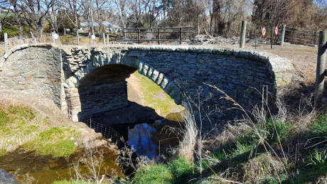
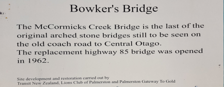
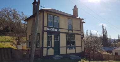
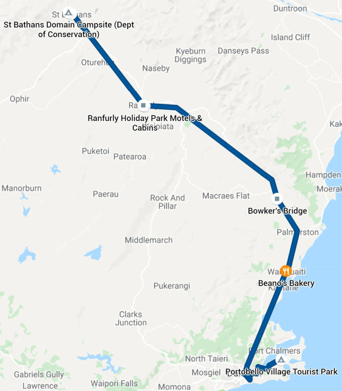
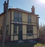
We set off at 9.30 driving back in sunshine along the Portobello Road which I would class as Scenic Drive 16. We were starting back towards Queenstwon, which we wanted to bypass, to look more closely at the West Coast. By 11.15 we arrived at Waikouarti a small town with a magnificent bakery called Beanos. We stocked up on their blueberry twists, some buns and their pies. This was an early lunch back in the van for us. Yummy! We had a nices45 min drive to Palmerston where we had to turn left on the R85 for Queenstown. Rolling hills, farms and some sea views. Where would we camp that night? We had to decide and after consulting the map and our smart phones decided on St Bathans, described as an historic gold town form the late 1800s. The land had dried out a lot on the way and we saw brownish fields with tussocks of golden grasses and no animals. Stopped at Bowkers Bridge - the last of the early stone bridges left on R 85 and also McCormicks Creek bridge. We were travelling through the foothills of the Oteake conservation park and treated to views of their snowy peaks. Arrived in St Bathans in the mid afternoon. One enigmatic old cottage with overgrown garden and a rusting small car still in its garage led us into the village. Some long deceased person had lived there and no-one had ever come to empty their cottage or even claim it as an inheritance. The lace curtains now in shreds still hung at the dirty windows: it was disturbing and sad. Further on some beautifully restored wooden buildings, a hotel, a post office and a stone two room cottage, all bordered the main street. On the other side the local river flowed between eroded cliffs of sandy dirt that had been blasted with water canon to release the gravel and gold that was then washed and collected. Untold damage to the river scape - a fate of many old gold towns of that period. A neat park with tables and chairs bordered the river but with stern warnings that no-one could camp there. Our GPS indicated the campin conservation park was on the other edge of town so we drove down past a few newer homes with neat gardens until we came to a gate that closed off the entrance to the local rugby field. An enigmatic sign made it difficult to decide if this really was the camping site, but it had the usual clean and well supplied toilet so we set up camp on the flat expanse of dead grass that appeared to be the edge of the sports field. Plenty of time to relax, sketch read and take stock of what we would do over the next few days.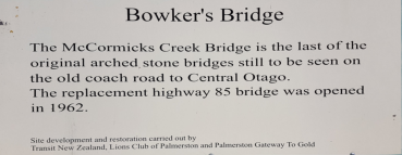

is an interesting small town with its historic stone and
weatherboard buildings and its scenic lake & clay cliffs. Camping
is allowed at the Lake as well as a sports ground on the outskirts
of the town.


© Greygypsies 2019
Formerly Dunstan Creek
now St Bathams
St Bathams
is an interesting small town with its
historic stone and weatherboard
buildings and its scenic lake & clay cliffs.
Camping is allowed at the Lake as well as
a sports ground on the outskirts of the
town.
St Bathams from Portobello via Bowkers
Bridge
We set off at 9.30 driving back in sunshine along the Portobello Road which I would class as Scenic Drive 16. We were starting back towards Queenstwon, which we wanted to bypass, to look more closely at the West Coast. By 11.15 we arrived at Waikouarti a small town with a magnificent bakery called Beanos. We stocked up on their blueberry twists, some buns and their pies. This was an early lunch back in the van for us. Yummy! We had a nices45 min drive to Palmerston where we had to turn left on the R85 for Queenstown. Rolling hills, farms and some sea views. Where would we camp that night? We had to decide and after consulting the map and our smart phones decided on St Bathans, described as an historic gold town form the late 1800s. The land had dried out a lot on the way and we saw brownish fields with tussocks of golden grasses and no animals. Stopped at Bowkers Bridge - the last of the early stone bridges left on R 85 and also McCormicks Creek bridge. We were travelling through the foothills of the Oteake conservation park and treated to views of their snowy peaks. Arrived in St Bathans in the mid afternoon. One enigmatic old cottage with overgrown garden and a rusting small car still in its garage led us into the village. Some long deceased person had lived there and no-one had ever come to empty their cottage or even claim it as an inheritance. The lace curtains now in shreds still hung at the dirty windows: it was disturbing and sad. Further on some beautifully restored wooden buildings, a hotel, a post office and a stone two room cottage, all bordered the main street. On the other side the local river flowed between eroded cliffs of sandy dirt that had been blasted with water canon to release the gravel and gold that was then washed and collected. Untold damage to the river scape - a fate of many old gold towns of that period. A neat park with tables and chairs bordered the river but with stern warnings that no-one could camp there. Our GPS indicated the campin conservation park was on the other edge of town so we drove down past a few newer homes with neat gardens until we came to a gate that closed off the entrance to the local rugby field. An enigmatic sign made it difficult to decide if this really was the camping site, but it had the usual clean and well supplied toilet so we set up camp on the flat expanse of dead grass that appeared to be the edge of the sports field. Plenty of time to relax, sketch read and take stock of what we would do over the next few days.