Breaden Hills


Mon 8th August : 175Km
68 sand dunes
Breaden Hills, Gravity Lake, Mt Romily & Mt Deviant(!)
7.45
Departed the camp site which was 2km N. of well 44 on R. this site could hold 10-12 cars. At well 44 there is room for 5-6 car sites.
We almost lost the last bag of children's jumpers we were carrying. Terry left it sitting on the roof when repacking the back seat this
morning. The Saunders spotted it in the middle of the track when they moved off.
Countryside looks much drier. Flowers are fewer and past their best and small shrubs seem to be dying of thirst round our camp site.
Driving through 2mt high avenues of shrubs crowding the track sides. Car mirrors have to be pulled in.
8.05
We are starting to see the first of the Northern Territory type termite mounds. These are the thin sheet ones; previous more scattered
termite mounds were large squat cones.
8.16
We drove along the l edge of a small lake on our right. The Pijallinga Claypan starts here on the map'. There were lots of wild ducks here
when Canning and his team came through in 1908 - 1910. Its dry at the moment despite the recent rains. Canning's men slaughtered
huge numbers of the ducks and their cook tried to preserve them in salt as they were short of meat this far north and supplies were low.
This did not preserve them and they had to be thrown out. Getting supplies to the men while the well making was under way was very
difficult. Canning had to make an 800km trip to bring fresh supplies in.
8.30
Several hill features appearing on the left as we cross a spinifex plain. Low hills on the left and rocky jump ups ahead with low hills in the
west leading into them. No names are recorded on the map for these hills. But as we passed a rocky escarpment of modest size on our
right, we named it Deviants Bluff. This name grew out of a joke I made calling an earlier deviation track from the main CSR -the Dillons
jumping onto a deviant!
8.35
As we crested a dune we came in sight of Gravity Lakes. In the distance.
8.40
Started to cross the salt pan of the Gravity Lake system. Wonderful smooth
surface after the rough ride of the CSR. Photos.
8.50
Back on the track with rocky bars and bad corrugations appearing.
Tinsel bush and pink pimelia appearing still.
9.05
Spotted a small grey cat on the track. Have seen a few cat tracks round some wells previously too.
9.10
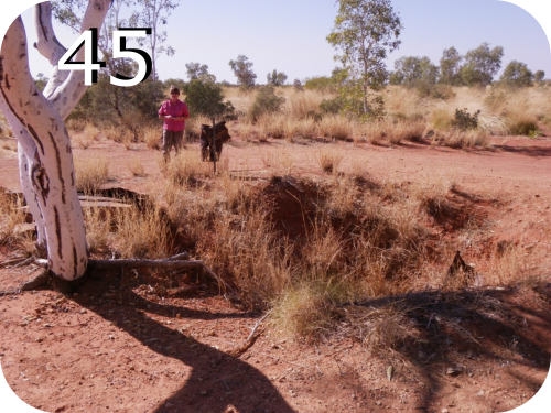
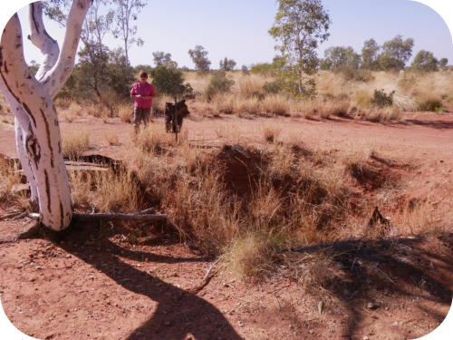
Arrived well 45. Abandoned with some rusty iron work scattered round the hole in the ground.
9.25
Passed a group of three south bound cars. Leaders chatted. They were led by a Brit from Lancashire (guess) called
Graeme.
9.55
Another salt pan lake in view on left. Not marked on map and more rocky bars for the next 5-10 minutes driving.
10.15
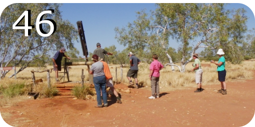
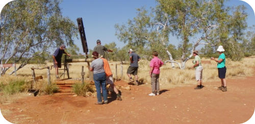
Arrived well 46 (Kuduarra well) reputedly a brown snake or diamond carpet snake lives in the well. Sign on the well
called it a "woma" or python.I certainly didn't see it but Terry claimed to see it tucked into a corner under a cavity
among some tree roots and a slight movement. All were taking photos. This well has water that can be drawn.
10.40
Departed well 46. Which was a very good campsite with shady white gums.
11.10
Have been passing small clumps of burnt melalueaca for the last 10 mins. Dave said a bushfire came through here in
2004.
11.45
Approached the 4km turnoff to well 47. We did not detour to it as it was cited as abandoned so we stayed on track. Heading to the Breaden
Pools in the Breaden Valley. We are travelling through flat open spinifex plains with scattered trees.
12.15
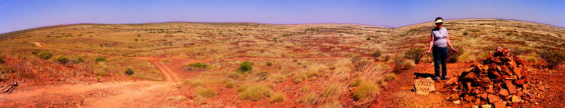
Some hill features on the skyline. Came up to them and saw car tracks climbing one to a great lookout on top. All cars climbed up and saw
the great 360 degree views. A recent cairn with a stone sign "Curley's Camp" suggested that someone with time to spare had camped on
top recently. It would be a very windy bare site to camp but OK in a swag. Some cassia and mulla mulla on top, very warm with the
temperature around 34c. Terry drove the steep track down while the others were persuaded by their wives to retrace down the less steep
track we took up.
12.40
Unnamed hill feature on right with 3 cairns visible on top.
12.45
Mt Romily now visible on left along with several other features. These are low mesas and escarpment. We had a lunch stop on track in a
hot dry spot. Noticed a new low flower near lunch spot. Bush around 20-30 cm with tiny blue flowers and rubbery stems and small leaves.
Photo. Seems well adapted to the arid sands.
1.10
Departed lunch spot.
Starting to see lots of small Eucalypts of about 2m with big creamy-yellow flowers.
1.50
Arrived at the Breaden uplands or hills. The last two hours we have been driving through a generally large area with many small hills. The
Breadens are more impressive and stretch along the left for quite a distance. Terry took a stitch photo of these. Very impressive as we get
closer. They have a brooding quality and beg to be explored.
2.35
We turned off the CSR onto a track leading into the Breaden Hills. We were driving to Breaden Pool on a track inbetween two impressive
ranges of escarpments, on either side. This is one of the most spectacular drives of the trip. After about 20 minutes we arrived at a small
car park. We did the short walk to the pool where lots of large black and white butterflies were clustered round the moist edges of the pool.
Some evidence of a recent flood, but the water was uninviting with a scum on top, Lots of mosquitos too. We later saw some photos of the
Rogers group having a great splash and swim there some years earlier when it looked fresh and inviting. Several of our group climbed to
the back of the pool and searched behind the waterfall where they found some Aboriginal artwork on the walls. A strangler fig was also
well established on the rock face on the left and had dropped its aerial roots into the water. There was a musty smell and the dark walls of
the canyon helped make the spot deliciously cool on this hot day. Photos.
2.55
We departed to return to the CSR.
3.00
Well 48. Meg didn't get out of the car. “Enough of abandoned wells!” she cried. Formerly this was an important well with a large flow and
strategically situated to the junction of the Canning and Christmas creeks intersecting with both the CSR and the Godfrey Tank stock
route.
3.07
Departed well.
3.35
The track has been revealing a lot of interesting hill features as but we drive down it. One of the best was
"Chinamans Hat" on the left, now called Mt UFO, an interesting example of how different generations rename with
common cultural references. It looks like both a hat and an unidentified flying object, the latter being often "seen"
in the skies in the 1960s.
3.40
Passed the burnt out Ford Explorer of the side of the track. This is the only dead car we have seen on the track. Most cars get minor
damage on the track but still get through. Went into another avenue of scratchy shrubs close to the track. Mirrors in again!
4.15
Arrived well 49 (Lumba well). This is the second last well and we decided to camp here as our last night camp on the CSR. There is good
water in a functional well and room for about 15 or more cars. I'm totally stuffed and really tired. Couldn't be bothered showering after the
group put up the shower tents. Annie and Helen finally persuaded me to have a sluice down after dinner. They were right. Felt great
afterwards. We tucked our tent into a nice little spot surrounded by low scrub. Another group were camping further over just about to start
their south bound journey down the CSR. They knew some of our crew who joined them for an evening of high jinks. They had already had
some car trouble speeding up on the Tanami track. Good luck to them…I hope they manage the CSR better.


Breaden Hills

Breaden Hills, Gravity Lake, Mt Romily
& Mt Deviant(!)
7.45
Departed the camp site which was 2km N. of well 44 on R. this
site could hold 10-12 cars. At well 44 there is room for 5-6 car
sites.
We almost lost the last bag of children's jumpers we were
carrying. Terry left it sitting on the roof when repacking the back
seat this morning. The Saunders spotted it in the middle of the
track when they moved off.
Countryside looks much drier. Flowers are fewer and past their
best and small shrubs seem to be dying of thirst round our camp
site.
Driving through 2mt high avenues of shrubs crowding the track
sides. Car mirrors have to be pulled in.
8.05
We are starting to see the first of the Northern Territory type
termite mounds. These are the thin sheet ones; previous more
scattered termite mounds were large squat cones.
8.16
We drove along the l edge of a small lake on our right. The
Pijallinga Claypan starts here on the map'. There were lots of wild
ducks here when Canning and his team came through in 1908 -
1910. Its dry at the moment despite the recent rains. Canning's
men slaughtered huge numbers of the ducks and their cook tried
to preserve them in salt as they were short of meat this far north
and supplies were low. This did not preserve them and they had
to be thrown out. Getting supplies to the men while the well
making was under way was very difficult. Canning had to make an
800km trip to bring fresh supplies in.
8.30
Several hill features appearing on the left as we cross a spinifex
plain. Low hills on the left and rocky jump ups ahead with low hills
in the west leading into them. No names are recorded on the map
for these hills. But as we passed a rocky escarpment of modest
size on our right, we named it Deviants Bluff. This name grew out
of a joke I made calling an earlier deviation track from the main
CSR -the Dillons jumping onto a deviant!
8.35
As we crested a dune we came in sight of Gravity Lakes. In the
distance.
8.40
Started to cross the salt pan of the Gravity Lake system.
Wonderful smooth surface after the rough ride of the CSR. Photos.
8.50
Back on the track with rocky bars and bad corrugations
appearing.
Tinsel bush and pink pimelia appearing still.
9.05
Spotted a small grey cat on the track. Have seen a few cat tracks
round some wells previously too.
9.10
Arrived well 45. Abandoned with some
rusty iron work scattered round the
hole in the ground.
9.25
Passed a group of three south bound
cars. Leaders chatted. They were led
by a Brit from Lancashire (guess)
called Graeme.
9.55
Another salt pan lake in view on left. Not marked on map and
more rocky bars for the next 5-10 minutes driving.
10.15
Arrived well 46 (Kuduarra well)
reputedly a brown snake or diamond
carpet snake lives in the well. Sign on
the well called it a "woma" or python.I
certainly didn't see it but Terry claimed
to see it tucked into a corner under a
cavity among some tree roots and a slight movement. All were
taking photos. This well has water that can be drawn.
10.40
Departed well 46. Which was a very good campsite with shady
white gums.
11.10
Have been passing small clumps of burnt melalueaca for the last
10 mins. Dave said a bushfire came through here in 2004.
11.45
Approached the 4km turnoff to well 47. We did not detour to it as
it was cited as abandoned so we stayed on track. Heading to the
Breaden Pools in the Breaden Valley. We are travelling through flat
open spinifex plains with scattered trees.
12.15
Some hill features on the skyline. Came up to them and saw car
tracks climbing one to a great lookout on top. All cars climbed up
and saw the great 360 degree views. A recent cairn with a stone
sign "Curley's Camp" suggested that someone with time to spare
had camped on top recently. It would be a very windy bare site to
camp but OK in a swag. Some cassia and mulla mulla on top, very
warm with the temperature around 34c. Terry drove the steep
track down while the others were persuaded by their wives to
retrace down the less steep track we took up.
12.40
Unnamed hill feature on right with 3 cairns visible on top.
12.45
Mt Romily now visible on left along with several other features.
These are low mesas and escarpment. We had a lunch stop on
track in a hot dry spot. Noticed a new low flower near lunch spot.
Bush around 20-30 cm with tiny blue flowers and rubbery stems
and small leaves. Photo. Seems well adapted to the arid sands.
1.10
Departed lunch spot.
Starting to see lots of small Eucalypts of about 2m with big
creamy-yellow flowers.
1.50
Arrived at the Breaden uplands or hills. The last two hours we
have been driving through a generally large area with many small
hills. The Breadens are more impressive and stretch along the left
for quite a distance. Terry took a stitch photo of these. Very
impressive as we get closer. They have a brooding quality and beg
to be explored.
2.35
We turned off the CSR onto a track leading into the Breaden Hills.
We were driving to Breaden Pool on a track inbetween two
impressive ranges of escarpments, on either side. This is one of
the most spectacular drives of the trip. After about 20 minutes we
arrived at a small car park. We did the short walk to the pool
where lots of large black and white butterflies were clustered
round the moist edges of the pool. Some evidence of a recent
flood, but the water was uninviting with a scum on top, Lots of
mosquitos too. We later saw some photos of the Rogers group
having a great splash and swim there some years earlier when it
looked fresh and inviting. Several of our group climbed to the
back of the pool and searched behind the waterfall where they
found some Aboriginal artwork on the walls. A strangler fig was
also well established on the rock face on the left and had dropped
its aerial roots into the water. There was a musty smell and the
dark walls of the canyon helped make the spot deliciously cool on
this hot day. Photos.
2.55
We departed to return to the CSR.
3.00
Well 48. Meg didn't get out of the car. “Enough of abandoned
wells!” she cried. Formerly this was an important well with a large
flow and strategically situated to the junction of the Canning and
Christmas creeks intersecting with both the CSR and the Godfrey
Tank stock route.
3.07
Departed well.
3.35
The track has been revealing a lot of
interesting hill features as but we
drive down it. One of the best was
"Chinamans Hat" on the left, now
called Mt UFO, an interesting
example of how different generations rename with common
cultural references. It looks like both a hat and an unidentified
flying object, the latter being often "seen" in the skies in the
1960s.
3.40
Passed the burnt out Ford Explorer of the side of the track. This is
the only dead car we have seen on the track. Most cars get minor
damage on the track but still get through. Went into another
avenue of scratchy shrubs close to the track. Mirrors in again!
4.15
Arrived well 49 (Lumba well). This is the second last well and we
decided to camp here as our last night camp on the CSR. There is
good water in a functional well and room for about 15 or more
cars. I'm totally stuffed and really tired. Couldn't be bothered
showering after the group put up the shower tents. Annie and
Helen finally persuaded me to have a sluice down after dinner.
They were right. Felt great afterwards. We tucked our tent into a
nice little spot surrounded by low scrub. Another group were
camping further over just about to start their south bound journey
down the CSR. They knew some of our crew who joined them for
an evening of high jinks. They had already had some car trouble
speeding up on the Tanami track. Good luck to them…I hope they
manage the CSR better.