Yulara To Warakuna Roadhouse
We were all up and away early hoping to catch the 3pm session of the balloon release at Giles. It would be
worth the effort as it promised a good tour and history of the weather station. There are two releases of
weather monitoring balloons every day at the station.
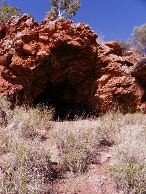
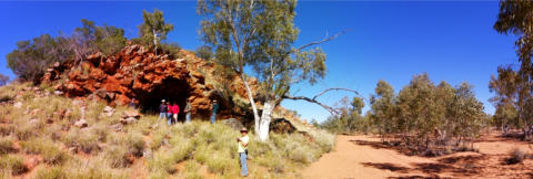
Lunch was taken at Lassiters Cave, the site where Lassiter sheltered while waiting for rescue after a failed
expedition to find a 'lost’ gold reef he had discovered on an earlier trip south west of Alice Springs. It's a lovely
dry creek bed with lots of shade trees and a commodious cave. Shame about the unlucky history. He spent 25
days sheltering there in a hot December, then pushed on to try and reached the Olgas but died of hunger and
thirst at the Ervin River. No-one has ever found the lost reef, but they still search. A grandson is the latest, who
was in the news after we returned. He believes he knows the site and is trying to raise interest in an
expedition. Apparently Lassiter described the reef as being around 7 miles (km?) long and 200
metres wide. It sometimes gets covered by drifting sand according to the grandson.
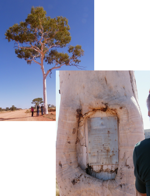
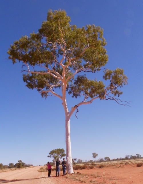
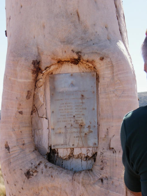
Sandy Blight Junction is just over the NT border in WA and was so named by Len Beadell who
surveyed and scraped the road in the 1950s. He marked a large white gum tree with a blaze
and tin sign of its name. He and his crew got a bad case of sandy blight eye infections when
putting the road in. We had looked forward to travelling on a "Beadell" road and since leaving
the Olgas had been travelling on the Gunbarrel Highway originally made by Len and his crew of
5-6 men. The 7000km of his roads which he pushed in the 1950s are mostly not maintained
now, but are sought after as four wheel drive tracks. Those he pushed round the Wimmera
Rocket Range are better looked after. I'm sure his roads will be again maintained in the near
future to cater for a growing tourist interest. We stopped at the tree as did another party of
three cars from NSW. The tree is a lovely specimen over 100ft high with a restored tin sign that
names the crew.
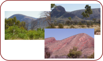
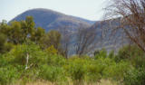
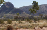
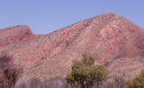
The scenery on the Gunbarrel Hwy near and over the WA border is spectacular, particularly round the Docker
River. Many ranges, jump ups and mesas abound. Great for paintings. We passed the Olia Range (on the left)
and the Petermann Ranges (on the right), then Bloods Range (left), Walter James Range (left), and some
great crescent closes near the road finishing in the Schwerin crescent (right). Great painting opportunities
here with the red colors of the hills and bright green of the new grasses and bushes.
That night we camped at the Warakurna Roadhouse at the start of the Rawlings Range. Sadly the old
Gunbarrel Hwy runs alongside this Range but is not travelled much and marked as
closed as it's in poor condition. We won't travel that way but we expect that many
others take a chance in order to get close to these ranges.
Tomorrow we will travel the Great Central Highway which finished at Leonora,
another gold town, but we will leave it at Warburton. The roadhouse is great with
super clean showers and camp kitchen where we cooked. It has a good shop and
selection of Aboriginal artworks priced between $400 to $800.
Unfortunately we arrived at 3pm so missed the afternoon Giles weather balloon
release so we will do it tomorrow morning. Nice happy hour. Helen led the women in
a pilates exercise session. After the session Meg felt good, but the hard rocky
ground didn't make it easy.


Lassiters Cave

Sun 21st July : 350Km


Yulara To Warakuna
Roadhouse
We were all up and away early hoping to catch
the 3pm session of the balloon release at Giles. It
would be worth the effort as it promised a good
tour and history of the weather station. There are
two releases of weather monitoring balloons
every day at the station.
Lunch was taken at Lassiters Cave, the site
where Lassiter sheltered while waiting for rescue
after a failed expedition to find a 'lost’ gold reef
he had discovered on an earlier trip south west of
Alice Springs. It's a lovely dry creek bed with lots
of shade trees and a commodious cave. Shame
about the unlucky history. He spent 25 days
sheltering there in a hot December, then pushed
on to try and reached the Olgas but died of
hunger and thirst at the Ervin River. No-one has
ever found the lost reef, but they still search. A
grandson is the latest, who was in the news after
we returned. He believes he knows the site and is
trying to raise interest in an expedition.
Apparently Lassiter described the reef as being
around 7 miles (km?) long and 200 metres wide.
It sometimes gets covered by drifting sand
according to the grandson.
Sandy Blight Junction is just over the NT border
in WA and was so named by Len Beadell who
surveyed and scraped the road in the 1950s. He
marked a large white gum tree with a blaze and tin sign of its name.
He and his crew got a bad case of sandy blight eye infections when
putting the road in. We had looked forward to travelling on a
"Beadell" road and since leaving the Olgas had been travelling on the
Gunbarrel Highway originally made by Len and his crew of 5-6 men.
The 7000km of his roads which he pushed in the 1950s are mostly
not maintained now, but are sought after as four wheel drive tracks.
Those he pushed round the Wimmera Rocket Range are better
looked after. I'm sure his roads will be again maintained in the near
future to cater for a growing tourist interest. We stopped at the tree
as did another party of three cars from NSW. The tree is a lovely
specimen over 100ft high with a restored tin sign that names the
crew.
The scenery on the Gunbarrel Hwy near and over the WA border is
spectacular, particularly round the Docker River. Many ranges, jump
ups and mesas abound. Great for paintings. We passed the Olia
Range (on the left) and the Petermann Ranges (on the right), then
Bloods Range (left), Walter James Range (left), and some great
crescent closes near the road finishing in the Schwerin crescent
(right). Great painting opportunities here
with the red colors of the hills and bright
green of the new grasses and bushes.
That night we camped at the Warakurna
Roadhouse at the
start of the
Rawlings Range. Sadly the old Gunbarrel
Hwy runs alongside this Range but is not
travelled much and marked as closed as it's
in poor condition. We won't travel that way
but we expect that many others take a
chance in order to get close to these ranges.
Tomorrow we will travel the Great Central
Highway which finished at Leonora, another
gold town, but we will leave it at Warburton.
The roadhouse is great with super clean
showers and camp kitchen where we cooked.
It has a good shop and selection of
Aboriginal artworks priced between $400 to $800.
Unfortunately we arrived at 3pm so missed the afternoon Giles
weather balloon release so we will do it tomorrow morning. Nice
happy hour. Helen led the women in a pilates exercise session. After
the session Meg felt good, but the hard rocky ground didn't make it
easy.
Lassiters Cave
Sun 21st July : 350Km
Sandy Blight Jn,
Docker River,
Warakuna


