Carnegie Station
Carnegie Station
We missed seeing the next Beadell tree, but several of our group spotted it as we sped past. Len Beadell marked trees both with a eye to posterity
and more practically to attach tin plates to them for the graders following so that they could confirm they were on the correct line. Although famed
for putting in straight line roads, in fact he often diverged to pass close to an attractive feature in the landscape: a clump of shade trees, an
attractive view, an interesting hill or rock formation. In his books he explained that he expected lots of travelling tourists to eventually use the
roads as well as long haulers and cattlemen. He wanted to make their trips comfortable and interesting.
The vegetation changed remarkably to claypans with carpets of pink and white wild flowers and lots of trees. Quite spectacular country. cassia
bush, emu bush of various colors, wattle and early sturt desert pea were all flung together by nature looking like spectacularly successful native
gardens. Few gardeners would be so successful though in creating such aesthetic displays. We started to see the first "snowdrops" - clusters of
white flowers on stand-up stalks in small rounded clumps about 10-15cm high and lots of different types of blue/mauve solenaceas.
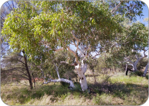
There were lots of great campsites on this section of the road in amongst the trees. Other parts of the Gunbarrel Hwy
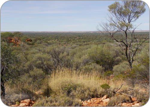
consisted of spinifex plains with some low bushes and an occasional tree here and there. In contrast the Mangrili Claypan
Nature Reserve was treed and full of flowers and worth spending more time than we had.We had morning tea by a small
lake near the road. It was full and had lots of birdlife amongst the trees. We found lots of blanks and chips along its shores,
so it has been a very old site of stone tool making. Small rounded rocks from the gibber plains were everywhere and were
used to create the tools. Was this area part of a glacial moraine? Oz was fully iced over many millions of years ago. Were
these water worn gibber stones carried by glaciers and dumped here as the glaciers started melting? Clearly this lake has
been a significant aboriginal site for a very long time.
Around 50 km further on we made a detour to drive to the top of Mt Nossitor. Terry and David drove to the top and parked. The rest of us walked
up. There was a trig point, good views and wildflowers at the top. Some sort of cairn with flowers apparently planted round it was there.
The Gunbarrel Hwy improved into a well graded road after the edge of the Nature Reserve. Between there and Carnegie Station we found easy
driving. If you want to get to the Reserve again, its best to travel east to it from Wiluna via Carnegie Station on the good
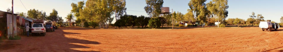
road. We arrived at Carnegie Station at 3pm. This gave us plenty of time to set up camp. The "Lone Traveller" was already
there when we arrived. A new management team (of 2?) had recently started work there. The camping area is run down.
Ablutions block, kitchen and store needs a lot of work done to bring it up to scratch; all is old, dirty and barely functional.
One loo of the two didn't work in the women's loo and shower block. It didn't flush and had frogs living in it! The shower
block was dirty and needed repairs. The camp kitchen was full of broken down stoves and had no running water for the
taps. The table and chairs were OK, but we had to cook food on the BBQ outside and bring our plates into the kitchen to
eat.
We were back in cattle country and the flies & mosquitoes were abundant and persistent.
Despite the drawbacks the tent area had shady trees and lawns to pitch tents on. We felt we were back in civilization again. We needed an early
night as we planned an 8am start for the morrow.


Sun 24th july : 240Km


Carnegie Station
Carnegie Station
We missed seeing the next Beadell tree, but several of our group spotted
it as we sped past. Len Beadell marked trees both with a eye to posterity
and more practically to attach tin plates to them for the graders following
so that they could confirm they were on the correct line. Although famed
for putting in straight line roads, in fact he often diverged to pass close
to an attractive feature in the landscape: a clump of shade trees, an
attractive view, an interesting hill or rock formation. In his books he
explained that he expected lots of travelling tourists to eventually use the
roads as well as long haulers and cattlemen. He wanted to make their
trips comfortable and interesting.
The vegetation changed remarkably to claypans with carpets of pink and
white wild flowers and lots of trees. Quite spectacular country. cassia
bush, emu bush of various colors, wattle and early sturt desert pea were
all flung together by nature looking like
spectacularly successful native gardens. Few
gardeners would be so successful though in
creating such aesthetic displays. We started to see
the first "snowdrops" - clusters of white flowers
on stand-up stalks in small rounded clumps about
10-15cm high and lots of different types of
blue/mauve solenaceas.
There were lots of great campsites on this
section of the road in amongst the trees. Other
parts of the Gunbarrel Hwy consisted of spinifex
plains with some low bushes and an occasional
tree here and there. In contrast the Mangrili
Claypan Nature Reserve was treed and full of
flowers and worth spending more time than we
had.We had morning tea by a small lake near the road. It was full and
had lots of birdlife amongst the trees. We found lots of blanks and chips
along its shores, so it has been a very old site of stone tool making.
Small rounded rocks from the gibber plains were everywhere and were
used to create the tools. Was this area part of a glacial moraine? Oz was
fully iced over many millions of years ago. Were these water worn gibber
stones carried by glaciers and dumped here as the glaciers started
melting? Clearly this lake has been a significant aboriginal site for a very
long time.
Around 50 km further on we made a detour to drive to the top of Mt
Nossitor. Terry and David drove to the top and parked. The rest of us
walked up. There was a trig point, good views and wildflowers at the top.
Some sort of cairn with flowers apparently planted round it was there.
The Gunbarrel Hwy improved into a well graded road after the edge of
the Nature Reserve. Between there and Carnegie Station we found easy
driving. If you want to get to the Reserve again, its best to travel east to
it from Wiluna via Carnegie Station on the good road. We arrived at
Carnegie Station at 3pm. This gave us plenty of time to set up camp. The
"Lone Traveller" was already there when we arrived. A new management
team (of 2?) had recently started work there. The camping area is run
down. Ablutions block, kitchen and store needs a lot of work done to
bring it up to scratch; all is old, dirty and barely functional. One loo of
the two didn't work in the women's loo and shower block. It didn't flush
and had frogs living in it! The shower block was dirty and needed repairs.
The camp kitchen was full of broken down stoves and had no running
water for the taps. The table and chairs were OK, but we had to cook
food on the BBQ outside and bring our plates into the kitchen to eat.
We were back in cattle country and the flies & mosquitoes were abundant
and persistent.
Despite the drawbacks the tent area had shady trees and lawns to pitch
tents on. We felt we were back in civilization again. We needed an early
night as we planned an 8am start for the morrow.
Sun 24th july : 240Km


